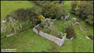
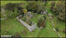
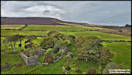
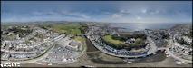
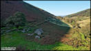
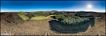
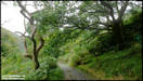
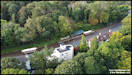
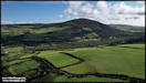
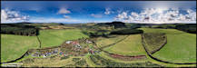
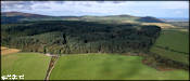
2/9/23
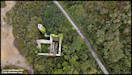
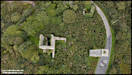
Yesterday afternoon
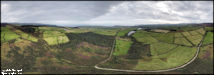
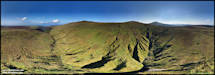
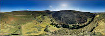
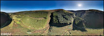
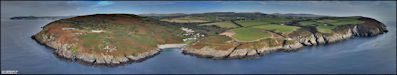
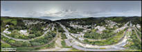
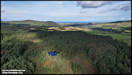
I tried a couple of 'comparison' flights, to compare 360 degree panoramas
shot on the 'Litchi' control app with my custom settings, with the DJI
'Fly' app's automatic panorama settings. The weather, which had been
bright and sunny for most of the afternoon, had clouded over by the time
that I was able to go flying and I had also forgotten that the 'Fly' app
locks the exposure settings for the whole sequence on those of the first
picture, which ended up with them being around a whole stop underexposed.
However, the PtGui app that I use to stitch the panoramas did a sterling
job of making them usable! Overall conclusion was that although using
my settings in 'Litchi' makes for a much more adaptable end product, the
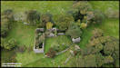
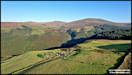
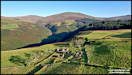
DJI 'Fly' app also does a good job. The location used was the tholtan
of Honey Hill Farm, reached by a greenway road off the Creg-ny-Baa back
road. The single shots are a mixture of 'Litchi' and 'Fly' originated
pictures.
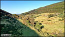
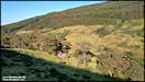
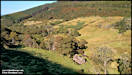
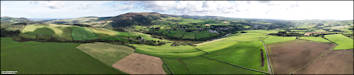
DJI Mini 2 1/9/23
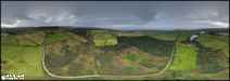
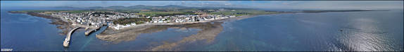
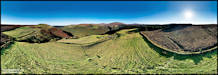
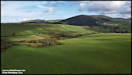
    On to the comparison
panoramas. The first two were 78 image 'HDR' shoots using the Litchi
app.
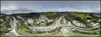
On to the comparison
panoramas. The first two were 78 image 'HDR' shoots using the Litchi
app.
 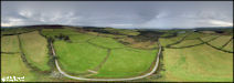 The next three panoramas
were 26 image shoots using the DJI Fly app.
The next three panoramas
were 26 image shoots using the DJI Fly app.
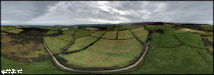  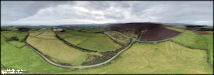 Overall I was a little
disappointed with the results shot by 'Fly', but they did have a third
less images to work with then the 'Litchi' produced one. Also, me
forgetting that the exposure is automatically locked after the first shot
by 'Fly' didn't help matters, although I suspect that if I'd shot the panoramas
with the ground correctly exposed, the sky would have 'burned out'.
As far as I can tell there is no way in 'Fly' to shoot panoramas with multiple
'AEB' exposures.
An almost full moon
shot from home.
Panasonic FZ82 1/9/23
Overall I was a little
disappointed with the results shot by 'Fly', but they did have a third
less images to work with then the 'Litchi' produced one. Also, me
forgetting that the exposure is automatically locked after the first shot
by 'Fly' didn't help matters, although I suspect that if I'd shot the panoramas
with the ground correctly exposed, the sky would have 'burned out'.
As far as I can tell there is no way in 'Fly' to shoot panoramas with multiple
'AEB' exposures.
An almost full moon
shot from home.
Panasonic FZ82 1/9/23
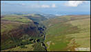
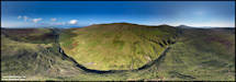
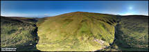
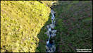
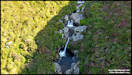
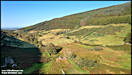
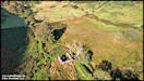
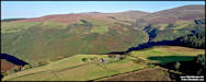
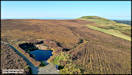
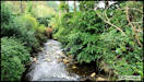
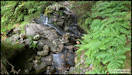
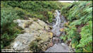
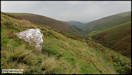
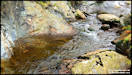
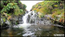
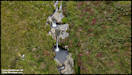
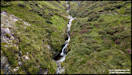
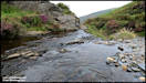
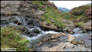
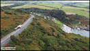
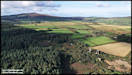
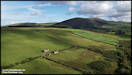
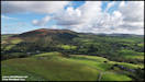
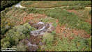
 3/9/23
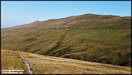
I had a walk out yesterday
afternoon to locate some of the 'hidden' waterfalls in the upper section
of Glen Auldyn. They're not really hidden, just hard to get to!
I started out from Mountain Box on the Mountain Road and walked down into
the glen from there, not very far in a linear (as on the map) distance,
but a descent of around 600 ft from the road (and then back up again!).
I didn't really leave enough time to properly explore and I was pleased
to have the drone to take most of the pictures for me, as I wasn't convinced
that some of the waterfalls were really accessible from ground level.
DJI Mini 2 2/9/23
3/9/23
I had a walk out yesterday
afternoon to locate some of the 'hidden' waterfalls in the upper section
of Glen Auldyn. They're not really hidden, just hard to get to!
I started out from Mountain Box on the Mountain Road and walked down into
the glen from there, not very far in a linear (as on the map) distance,
but a descent of around 600 ft from the road (and then back up again!).
I didn't really leave enough time to properly explore and I was pleased
to have the drone to take most of the pictures for me, as I wasn't convinced
that some of the waterfalls were really accessible from ground level.
DJI Mini 2 2/9/23
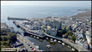
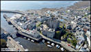
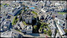
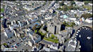
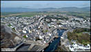
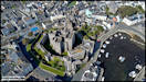
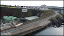
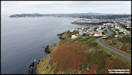
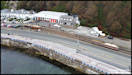
 4/9/23
It's been a while since
I photographed Castletown from the air. Despite holding CAA permissions
for drone flying within 5 Km of the airport, Air Traffic Control restrictions
make fitting in drone flying between other movements very difficult, but
I had identified that a few 'windows' existed at present. The airport
is still very short of qualified controllers and has to close for 35 minutes
on several occasions through the day to fit in legally required fatigue
breaks for them, during which the controlled airspace around the airport
is disestablished. One of those is currently between 11:00 and 11:35 local
time, so after checking with ATC that they would actually be closing, I
managed to get these pictures. The time wasn't ideal either for lighting
or tide state, but you have to work with what you can get.
DJI Mini 2 3/9/23
4/9/23
It's been a while since
I photographed Castletown from the air. Despite holding CAA permissions
for drone flying within 5 Km of the airport, Air Traffic Control restrictions
make fitting in drone flying between other movements very difficult, but
I had identified that a few 'windows' existed at present. The airport
is still very short of qualified controllers and has to close for 35 minutes
on several occasions through the day to fit in legally required fatigue
breaks for them, during which the controlled airspace around the airport
is disestablished. One of those is currently between 11:00 and 11:35 local
time, so after checking with ATC that they would actually be closing, I
managed to get these pictures. The time wasn't ideal either for lighting
or tide state, but you have to work with what you can get.
DJI Mini 2 3/9/23
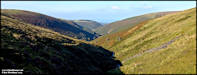
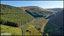
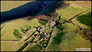
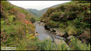
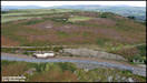
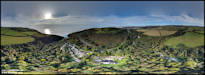
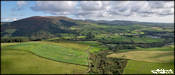
 5/9/23
Yesterday afternoon
I visited the 'Hidden Valley', Glen Dhoo, which is to the south of Ballaugh.
Always a lovely and peaceful location, I made a slight navigation error
setting off from where I parked the car and walked along totally the wrong
(very steep!) path before realising that it might not be the correct way
and consulting the GPS. A backtrack was needed which delayed my arrival
until after the shadows were starting to creep dow the western hillside.
DJI Air 2S 4/9/23
5/9/23
Yesterday afternoon
I visited the 'Hidden Valley', Glen Dhoo, which is to the south of Ballaugh.
Always a lovely and peaceful location, I made a slight navigation error
setting off from where I parked the car and walked along totally the wrong
(very steep!) path before realising that it might not be the correct way
and consulting the GPS. A backtrack was needed which delayed my arrival
until after the shadows were starting to creep dow the western hillside.
DJI Air 2S 4/9/23
 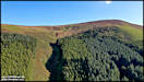  
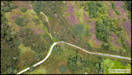
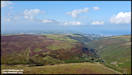
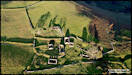
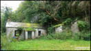
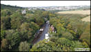
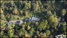
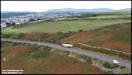
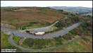
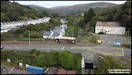
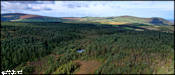
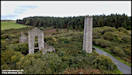
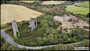
  6/9/23
On the way home from
the Glen Dhoo walk, I had a brief stop just off the Druidale road to shoot
some aerial pictures of the Killabrega tholtan above Sulby Glen.
I might have been a longer flight, but the midgies put in an appearance
and I curtailed the flight quickly!
DJI Air 2S 4/9/23
6/9/23
On the way home from
the Glen Dhoo walk, I had a brief stop just off the Druidale road to shoot
some aerial pictures of the Killabrega tholtan above Sulby Glen.
I might have been a longer flight, but the midgies put in an appearance
and I curtailed the flight quickly!
DJI Air 2S 4/9/23
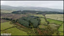
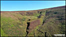
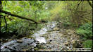
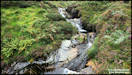
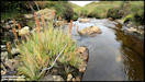
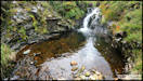
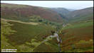
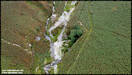
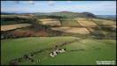
 8/9/23
Yesterday I decided
to try and reach the waterfalls in upper Glen Auldyn again, this time walking
up the glen and leaving more time that before. I hadn't realised
quite how much altitude you gain on the walk up, from the map it's around
800 ft, but the GPS recorded over 1,000 ft probably due to me climbing
up and down various hillsides trying to access the waterfalls. Trying
to save weight in the rucksack, I didn't take a 'proper' camera, just the
GoPro, plus the Mini 2 drone in case I wanted any aerial shots. Bit
of a mistake really, as the GoPro is very much a 'point and shoot' camera
and I really don't like the on screen swapping between modes, which seen
really easy to inadvertently select!
GoPro Hero 9 & DJI
Mini 2 7/9/23
8/9/23
Yesterday I decided
to try and reach the waterfalls in upper Glen Auldyn again, this time walking
up the glen and leaving more time that before. I hadn't realised
quite how much altitude you gain on the walk up, from the map it's around
800 ft, but the GPS recorded over 1,000 ft probably due to me climbing
up and down various hillsides trying to access the waterfalls. Trying
to save weight in the rucksack, I didn't take a 'proper' camera, just the
GoPro, plus the Mini 2 drone in case I wanted any aerial shots. Bit
of a mistake really, as the GoPro is very much a 'point and shoot' camera
and I really don't like the on screen swapping between modes, which seen
really easy to inadvertently select!
GoPro Hero 9 & DJI
Mini 2 7/9/23

   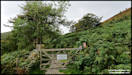 
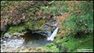    
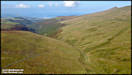
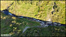
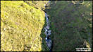
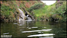
    Some aerial pics.
     Back at ground level
and starting to make my way back down the glen.
Back at ground level
and starting to make my way back down the glen.
    9/9/23
Sunset from Birch Hill.
I had just gone upstairs for something and took a look out of the window
at the sunset. The sun was just about to vanish behind Slieau Whallian
with a distinctive cloud above it, so I rushed to get a camera to record
it.
Panasonic TZ200 8/9/23
9/9/23
Sunset from Birch Hill.
I had just gone upstairs for something and took a look out of the window
at the sunset. The sun was just about to vanish behind Slieau Whallian
with a distinctive cloud above it, so I rushed to get a camera to record
it.
Panasonic TZ200 8/9/23
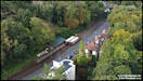
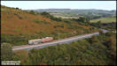
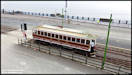
  11/9/23
On the 7th September
1893, the Manx Electric Railway carried its first fare paying passengers
on a fairly short single track line between Derby Castle, Douglas and Groudle
Glen. Constructed by the Douglas and Laxey Coast Electric Tramway
Company, they also built the road running alongside the tramway, a hotel
at Groudle and 'rustic walks' within the glen. Running for that season
only lasted for 19 days but in that time they carried more than 20,000
passengers. By the time the line reopened in May 1894 the original
single line had been doubled and construction onwards toward Laxey was
in full swing, the line to there opening in July of the same year, an amazing
feat! In the fullness of time the line was extended all the way to
Ramsey, being completed in 1899.
Yesterday, the 10th
September, a special celebration of the original line's 130th anniversary
was held, with parallel running by the two surviving original 1893 cars
and an intensive service to Laxey, where H.E. the Lieutenant Governor unveiled
a commemorative plaque, with a band entertaining visitors and a 'Victorian
Fair'.
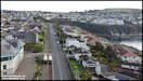
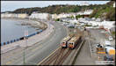
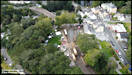
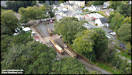
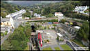
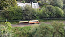
I decided to try something
a bit different, taking aerial shots of the trams in several locations
between Douglas and Laxey. Normally I would have put these into the
separate 'Railways' section, but as they are more of the nature of 'Trams
in the Landscape' I though that they should go into the general section.
DJI Mini 2 10/9/23
11/9/23
On the 7th September
1893, the Manx Electric Railway carried its first fare paying passengers
on a fairly short single track line between Derby Castle, Douglas and Groudle
Glen. Constructed by the Douglas and Laxey Coast Electric Tramway
Company, they also built the road running alongside the tramway, a hotel
at Groudle and 'rustic walks' within the glen. Running for that season
only lasted for 19 days but in that time they carried more than 20,000
passengers. By the time the line reopened in May 1894 the original
single line had been doubled and construction onwards toward Laxey was
in full swing, the line to there opening in July of the same year, an amazing
feat! In the fullness of time the line was extended all the way to
Ramsey, being completed in 1899.
Yesterday, the 10th
September, a special celebration of the original line's 130th anniversary
was held, with parallel running by the two surviving original 1893 cars
and an intensive service to Laxey, where H.E. the Lieutenant Governor unveiled
a commemorative plaque, with a band entertaining visitors and a 'Victorian
Fair'.
I decided to try something
a bit different, taking aerial shots of the trams in several locations
between Douglas and Laxey. Normally I would have put these into the
separate 'Railways' section, but as they are more of the nature of 'Trams
in the Landscape' I though that they should go into the general section.
DJI Mini 2 10/9/23
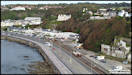    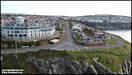
   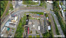  Although the main reason
for yesterday's flights was to take pictures of the Manx Electric trams,
I was also sidetracked into a few panoramas!
Although the main reason
for yesterday's flights was to take pictures of the Manx Electric trams,
I was also sidetracked into a few panoramas!
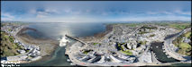
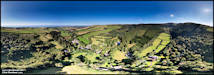
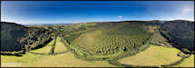
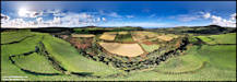
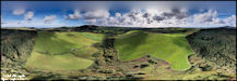
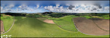
  14/9/23
I hadn't planned in
advance for these flights, but the conditions looked good first thing in
the morning yesterday and after breakfast I set out to Archallagan Plantation,
with the intention of mainly shooting some 360 degree panoramas.
I flew from two locations, on either side of the large plantation.
DJI Air 2S 13/9/23
14/9/23
I hadn't planned in
advance for these flights, but the conditions looked good first thing in
the morning yesterday and after breakfast I set out to Archallagan Plantation,
with the intention of mainly shooting some 360 degree panoramas.
I flew from two locations, on either side of the large plantation.
DJI Air 2S 13/9/23
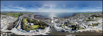
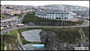
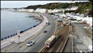
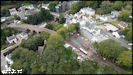
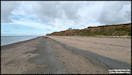
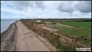
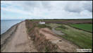
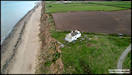
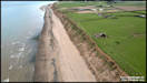
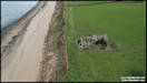
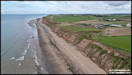
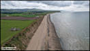
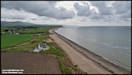
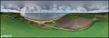
  15/9/23
Yesterday afternoon
I went for a walk along the beach south of Jurby Head, taking a drone with
me to get some pictures of the eroding sandy cliffs here and particularly
of two old houses that are getting ever closer to the cliff edge, although
there seems to be some work being carried out at one. I had hoped
for some brighter weather, but in the end the sun hid behind clouds all
the time that I was there!
DJI Air 2S 14/9/23
15/9/23
Yesterday afternoon
I went for a walk along the beach south of Jurby Head, taking a drone with
me to get some pictures of the eroding sandy cliffs here and particularly
of two old houses that are getting ever closer to the cliff edge, although
there seems to be some work being carried out at one. I had hoped
for some brighter weather, but in the end the sun hid behind clouds all
the time that I was there!
DJI Air 2S 14/9/23
    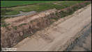
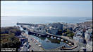
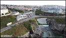
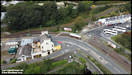
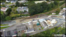
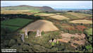
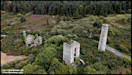
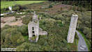
 After finishing the
flight from the beach, I considered walking up to Jurby Head to view the
'Pasages' shipwreck, but decided against it as I would have had to wait
for quite a long time for the tide to uncover it. Instead I headed
back south in the car to Cornelly Mine, to take some closer aerial pictures
of it.
DJI Mini 2 14/9/23
After finishing the
flight from the beach, I considered walking up to Jurby Head to view the
'Pasages' shipwreck, but decided against it as I would have had to wait
for quite a long time for the tide to uncover it. Instead I headed
back south in the car to Cornelly Mine, to take some closer aerial pictures
of it.
DJI Mini 2 14/9/23
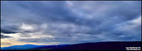
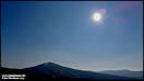
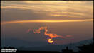
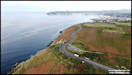
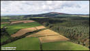
     27/10/23
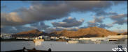
For the latter part
of September and most of October, we were away from the Isle of Man, ataying
on our second adopted island home of Lanzarote, in the Canary Island.
This is an evening view of the mountains from the back garden of our rented
villa in Playa Blanca.
Panasonic FZ72 23/9/23
27/10/23
For the latter part
of September and most of October, we were away from the Isle of Man, ataying
on our second adopted island home of Lanzarote, in the Canary Island.
This is an evening view of the mountains from the back garden of our rented
villa in Playa Blanca.
Panasonic FZ72 23/9/23
|